DIGITAL ELEVATION MODELS
GENERAL INFORMATION

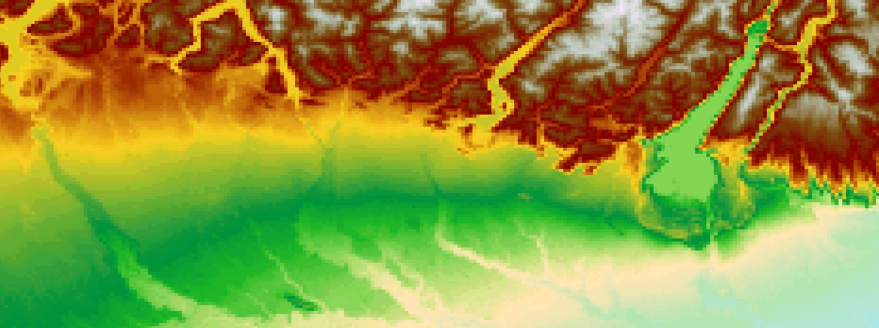
Digital Elevation Models (DEMs) are fundamental geospatial datasets used to represent the elevation information of the Earth’s surface. They provide a detailed and accurate representation of the terrain, capturing variations in height across landscapes, including terrain features, vegetation, buildings, and other objects. They serve as the foundation for various analyses, simulations, and visualizations that require precise elevation data and are essential in several applications, from large-scale topographic mapping to fine-scale engineering projects, including terrain analysis, land use planning, environmental modeling, and 3D visualization.
The DEM is derived from remote sensing data collected by various sensors, including LiDAR (Light Detection and Ranging), photogrammetry, and Radar technologies like SRTM (Shuttle Radar Topography Mission) and Sentinel-1.
The spatial resolution of DEMs varies, ranging from coarse resolutions of tens to hundreds of meters for global coverage to fine resolutions of a few centimeters for local and specialized applications. High-resolution DEMs are vital for urban planning, infrastructure design, and precision agriculture, where fine details of the terrain are crucial. On the other hand, coarser DEMs find applications in regional planning, geological studies, and large-scale environmental assessments. As technology advances, the availability and accuracy of DEMs continue to improve, further enhancing our understanding and utilization of elevation data for a sustainable future.
DEM, DTM, and DSM
- Digital Elevation Model (DEM): A DEM provides a digital generalized representation of the Earth’s surface, offering elevation data for the ground surfaces, hills, valleys, and other natural landforms. DEMs are extensively used in various applications, including hydrology, soil analysis, and land use planning. They are valuable for terrain analysis, flood modeling, and identifying potential landslide areas.
- Digital Terrain Model (DTM): A DTM is like a DEM in that it represents the elevation of the Earth’s ground surface. However, a DTM includes certain above-ground features such as bridges, roads, and other essential ground infrastructure. It provides a comprehensive terrain model, incorporating certain anthropogenic features. DTMs find applications in civil engineering projects, transportation planning, and terrain visualization for urban development.
- Digital Surface Model (DSM): A DSM represents the elevation of the Earth’s surface, capturing not only the bare terrain but also all above-ground features such as buildings, vegetation, and bridges. It provides a comprehensive representation of the Earth’s surface, including both natural and built features. DSMs are crucial for 3D modeling applications, including telecommunications network planning, urban development, and aviation simulations. They enable accurate landscape visualization, improving spatial planning, environmental analysis, and urban growth management.
DERIVATION OF DEM FROM REMOTE SENSING DATA
Remote sensing technologies offer various methods to derive Digital Elevation Models (DEMs) representing Earth’s terrain and object heights, including LiDAR, photogrammetry, and radar technologies.
- LiDAR Technology: Light Detection and Ranging (LiDAR) is a remote sensing technology that uses laser pulses to measure distances between the sensor and the Earth’s surface. LiDAR sensors emit laser beams, and the time taken for the laser to return after hitting the surface is recorded. By combining the time-of-flight data with the position and orientation of the sensor, LiDAR can generate highly accurate and dense point clouds representing the 3D structure of the terrain and objects.
- Photogrammetry: Photogrammetry is another technique used to derive DEMs from remote sensing data. It involves the extraction of elevation information from overlapping aerial or satellite images. By identifying corresponding points in multiple images and using stereo-photogrammetric techniques, elevation values are interpolated to create a DEM.
- Radar Technologies: Radar-based sensors, such as those on the Shuttle Radar Topography Mission (SRTM) and the Sentinel-1 satellites, are used to derive DEMs. These radar systems use microwave pulses to measure the time taken for the signal to bounce back from the Earth’s surface, allowing the reconstruction of the terrain’s elevation. SRTM, for example, has provided global DEM data at a resolution of approximately 90 meters, while Sentinel-1 offers high-resolution DEMs with a spatial resolution of 10 meters in the Interferometric Wide Swath (IW) mode.
The Table provides a summary of the main sensors used for DEM generation, their spatial resolutions, and typical scales of applications:
| Sensor | Spatial Resolution | Typical Scale of Applications |
| LiDAR | Very High (sub-meter) | Local-scale terrain analysis, 3D modeling, forestry management |
| Photogrammetry | High (decimeters) | Regional-scale mapping, urban planning, engineering projects |
| Sentinel-1 | High (10m) | Local to regional-scale terrain mapping, environmental studies |
| SRTM | Medium to Low (30-90m) | Global-scale topographic mapping, large-area analysis |
DERIVED PRODUCTS FROM DEM

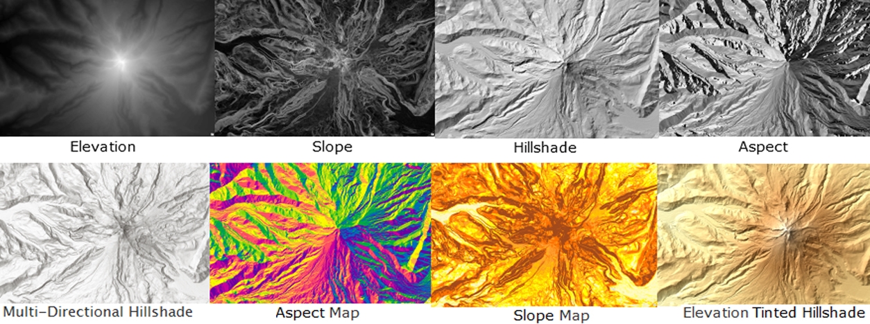
Digital Elevation Models (DEMs) serve as valuable sources of elevation data, enabling the derivation of essential terrain-related products. Derived products include slope, aspect, hillshade, sky-view factor, and canopy height models, providing crucial insights for diverse applications such as terrain analysis, weather modeling, urban planning, and environmental monitoring.
- Slope: Slope is a fundamental topographic parameter derived from DEM data, representing the steepness of the terrain surface. It is calculated as the rate of change in elevation per unit distance. Steeper slopes indicate rugged terrain, while gentler slopes typically characterize flatter regions. Slope information is vital for various applications, such as terrain stability analysis, hydrological modeling, and identifying potential landslide-prone areas.
- Aspect: Aspect refers to the compass direction that a slope faces. It is derived from DEM data and indicates the direction in which a terrain surface is oriented. Aspect is expressed in degrees, representing the azimuth angle from 0° (north) to 360° (clockwise). Aspect information is crucial for understanding the exposure of slopes to sunlight, which influences factors such as microclimate, vegetation distribution, and snowmelt patterns.
- Hillshade: Hillshade is a visualization product created from DEM data, simulating the illumination of the terrain with a virtual light source. It generates a 3D-like representation of the terrain, enhancing its visual appearance and revealing subtle terrain features. Hillshade maps are widely used for cartographic purposes and in 3D visualization applications.
- Sky-View Factor (SVF): The Sky-View Factor (SVF) is a derived product that quantifies the openness of a given location to the sky. It is calculated based on the proportion of visible sky when looking upward from a specific point on the terrain. High SVF values indicate more open areas with good visibility of the sky, while low SVF values suggest areas with limited sky visibility, such as urban canyons.
- Canopy Height Model (CHM): The Canopy Height Model (CHM) is a product derived from DEM data that represents the height of vegetation above the ground. It is obtained by subtracting the Digital Terrain Model (DTM) from the Digital Surface Model (DSM). CHMs are essential for forest monitoring, tree height estimation, monitoring forest health, biomass estimation, and vegetation structure analysis.
MAIN APPLICATIONS OF DEM
- Urban Planning and Infrastructure Development: DEMs are valuable for urban planning and infrastructure design, providing insights into the topography of urban areas, flood risk assessment, and optimal site selection for construction projects.
- Environmental Modeling: DEMs and derived products play a significant role in environmental modeling, such as hydrological modeling, water flow analysis, and identifying erosion-prone areas.
- Forestry and Natural Resource Management: DEM-derived products like CHM are essential for forest inventory, tree height estimation, and monitoring forest health.
- Archaeology and Cultural Heritage: DEMs aid archaeologists in identifying and analyzing ancient landscapes, buried structures, and archaeological sites.
- Geology and Geological Mapping: DEMs assist geologists in understanding landforms, tectonic features, and geological structures.
- Climate Studies: DEM-derived slope and aspect information contribute to climate studies by influencing local weather patterns, solar radiation distribution, and microclimates.
RELATED LINKS AND ADDITIONAL RESOURCES
Further background information about DEM
- USGS – What is a digital elevation model (DEM)?: This page provided by the United States Geological Survey (USGS) offers information on what a Digital Elevation Model (DEM) is, how it is created, and its main technical features. A DEM is a representation of the bare ground topographic surface of the Earth, excluding trees, buildings, and any other surface objects. DEMs are created from a variety of sources and are used in many applications, including hydrology, land use planning, and geographic information systems.
- NASA Earthdata: This website provided by NASA offers access to a wide range of Earth science data, including DEM data from various satellite missions.
- ESA – Copernicus DEM: This page provided by the European Space Agency (ESA) offers information on the Copernicus DEM, a global and consistent high-resolution DEM available to all its users to address a variety of applications. The Copernicus DEM is available in 30 metre and 90 metre resolution globally, as well as in 10 metre for the EEA39 area.
- NASA Earthdata – NASADEM: This page provided by NASA Earthdata offers information on NASADEM, a new NASA Digital Elevation Model that incorporates data from the Shuttle Radar Topography Mission (SRTM) and other sources, including the Advanced Spaceborne Thermal Emission and Reflection Radiometer (ASTER).
- NASA Earthdata – New Version of the ASTER GDEM: This page provided by NASA Earthdata offers information on the new version of the ASTER Global Digital Elevation Model (GDEM), which provides new features and sharper imagery.
- ASTER Digital Elevation Model – AST14DEM-Relative: This page provided by the Jet Propulsion Laboratory (JPL) offers information on the ASTER Digital Elevation Model (DEM) product derived using bands 3N and 3B from an ASTER Level-1A data set.
Accessing and working with DEM
- USGS EarthExplorer: EarthExplorer is a web-based search and order tool provided by the USGS. It offers access to a wide range of satellite and aerial data, including DEM data from the Shuttle Radar Topography Mission (SRTM) and the Advanced Spaceborne Thermal Emission and Reflection Radiometer (ASTER).
- Copernicus Open Access Hub: The Copernicus Open Access Hub, also known as the Copernicus Hub, provides complete, free, and open access to Sentinel-1, Sentinel-2, Sentinel-3, and Sentinel-5P user products. The Copernicus Hub does not provide access to DEM products. However, you can use the Sentinel-1 Synthetic Aperture Radar (SAR) data available on the Copernicus Hub to generate DEMs using SAR interferometry techniques.
- GIS Geography – 5 Free Global DEM Data Sources: This page provided by GIS Geography offers a list of 5 free global DEM data sources, including the Shuttle Radar Topography Mission (SRTM), the Advanced Spaceborne Thermal Emission and Reflection Radiometer (ASTER), and JAXA’s Global ALOS 3D World.
*Images from

