Local Climate Zones - LCZ
GENERAL INFORMATION


Local Climate Zones (LCZ) represent a sophisticated classification system devised to delineate urban areas based on their distinct surface cover, morphology, and thermal characteristics.
Initially introduced by Stewart and Oke in 2012, LCZ has emerged as a pivotal tool in comprehending the intricate microclimates within urban environments, facilitating a nuanced understanding of urban climatology and its implications for urban planning, environmental management, and public health.
Urban areas constitute complex and dynamic systems characterized by diverse land uses, building typologies, and surface materials, which profoundly influence local climate conditions. The spatial heterogeneity inherent to urban landscapes causes significant variations in temperature, humidity, wind patterns, and other climatic parameters across different urban typologies, giving rise to localized microclimates that can diverge substantially from regional climatic norms.
LCZ offers a systematic framework for categorizing and characterizing the variety of urban environments, enabling planners, researchers, and policymakers to discern patterns, trends, and anomalies in urban climatology. By delineating urban areas into discrete LCZ classes, ranging from compact high-rise urban cores to expansive vegetated parks and water bodies, LCZ provides a standardized taxonomy for interpreting and analyzing urban microclimates, facilitating cross-disciplinary research and collaboration in urban climatology.
The classification of urban areas into LCZ classes is predicated on a comprehensive assessment of surface cover, building morphology, vegetation density, impervious surface area, and other key parameters that influence the thermal behavior of urban environments. These parameters serve as proxies for the underlying physical processes driving urban microclimates, including radiative heat exchange, convective heat transfer, and latent heat fluxes, which play critical roles in shaping temperature distributions, wind patterns, and other climatic phenomena within cities.
Central to the utility of LCZ is its ability to capture the multifaceted nature of urban climatology, accounting for the interplay between natural and anthropogenic factors that shape local climate conditions. Urban heat islands, for instance, represent a well-documented phenomenon whereby urban areas exhibit elevated temperatures compared to surrounding rural areas, owing to the absorption and retention of solar radiation by built surfaces and the suppression of cooling mechanisms such as evapotranspiration.
Moreover, LCZ classification extends beyond surface attributes to encompass broader morphological characteristics and urban form parameters that influence microclimatic processes. Tall buildings, for example, can induce canyon effects that affect air turbulence and heat exchange within urban canyons. At the same time, green spaces and water bodies serve as oases of coolness, moderating temperatures and mitigating the adverse impacts of heat islands.
In essence, LCZ represents a holistic approach to urban climatology that transcends traditional disciplinary boundaries, integrating insights from meteorology, geography, urban planning, and environmental science to unravel the complexities of urban microclimates.
By providing a standardized framework for classifying urban environments and quantifying their thermal properties, LCZ empowers stakeholders to make informed decisions regarding urban design, land use planning, and climate adaptation strategies, fostering resilient, sustainable, and livable cities in the face of ongoing urbanization and climate change.
LCZ SCHEME
The Local Climate Zones (LCZ) scheme is an all-encompassing system that classifies urban areas into 17 unique classes. Each class signifies a distinct urban typology characterized by its specific surface cover features, building morphology, and thermal behavior. These classes span a broad spectrum of urban environments, from densely built urban cores, known as built types (LCZ 1 to 10), to suburban areas characterized by sparse vegetation and primarily pervious surfaces, referred to as land cover types (LCZ A to G).
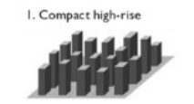 |
LCZ 1 – Compact High-Rise: This class comprises densely built urban areas characterized by tall buildings, more than 9 stories, with a high population density and limited or no vegetation cover. These areas typically include commercial and central business districts dominated by skyscrapers and high-rise residential buildings. |
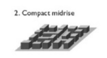 |
LCZ 2 – Compact Midrise: Like LCZ 1 but with slightly lower building heights, typically 3 to 9 stories, LCZ 2 includes mixed-use urban areas with mid-rise residential and commercial developments. These areas often feature a combination of office buildings, apartment complexes, and retail establishments. |
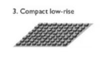 |
LCZ 3 – Compact Low-Rise: Denotes compact urban neighborhoods characterized by low-rise buildings, typically 1 to 3 stories, and a mix of residential and commercial land uses. These areas usually feature single-family homes, townhouses, and small-scale retail or office buildings. |
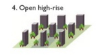 |
LCZ 4 – Open High-Rise: Represents urban areas with tall buildings, like LCZ 1, surrounded by extensive open spaces. These areas often include high-rise residential towers, office complexes, or institutional buildings within significant green spaces or large parks, plazas, or recreational areas. |
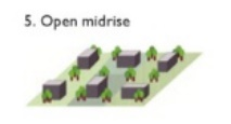 |
LCZ 5 – Open Midrise: Resembling LCZ 4 but with lower building heights, typically 3 to 9 stories, LCZ 5 encompasses urban areas characterized by mid-rise residential developments interspersed with significant green spaces, parks, or green corridors. |
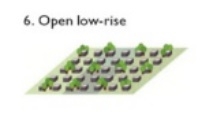 |
LCZ 6 – Open Low-Rise: Typically denotes suburban neighborhoods with predominantly low-rise buildings, 1 to 3 stories, and ample greenery. These areas usually feature single-family homes, townhouses, and low-density commercial developments with significant green spaces. |
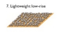 |
LCZ 7 – Lightweight Low-Rise: Represents suburban areas with low-density development, mainly a dense mix of single-story buildings and sparse or no vegetation. These areas often feature single-family homes, detached houses, or low-rise apartment buildings. |
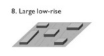 |
LCZ 8 – Large Low-Rise: Denotes sprawling suburban areas characterized by extensive low-rise developments, 1 to 3 stories, and minimal or no vegetation. These areas typically feature large lots, suburban subdivisions, and a mix of residential, commercial, and industrial land uses. |
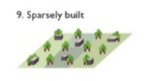 |
LCZ 9 – Sparsely Built: Includes areas with minimal urban development and sparse vegetation, including small and medium-sized buildings in natural settings. Typically represents undeveloped land on the urban fringe. |
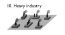 |
LCZ 10 – Heavy Industry: Represents areas with intensive industrial activity characterized by large-scale manufacturing facilities, warehouses, and industrial infrastructure. These areas typically exhibit high levels of impervious surfaces and limited or no vegetation. |
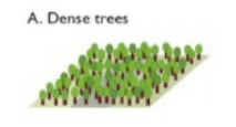 |
LCZ A – Dense Trees: Denotes areas dominated by dense tree canopy cover and limited or no built infrastructure. Represents heavily wooded landscapes of deciduous and/or evergreen trees, such as forests, nature reserves, and urban parks with high vegetation density. |
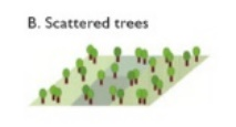 |
LCZ B – Scattered Trees: Features lightly wooded landscapes of deciduous and/or evergreen trees or scattered tree cover amidst low-density development. |
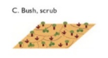 |
LCZ C – Bush, scrub: Represents areas characterized by shrubs, scrubland, and sparse tree cover, such as semi-natural landscapes, agriculture, degraded areas, and urban fringes. |
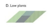 |
LCZ D – Low plants: Encompasses areas with low-growing vegetation and minimal tree cover, including grasslands, agriculture, meadows, and green spaces with low vegetation density, including urban parks. |
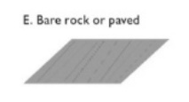 |
LCZ E – Bare rock or paved: Denotes areas with exposed rock surfaces, paved areas, and minimal or no vegetation, such as roads, parking lots, and industrial sites. |
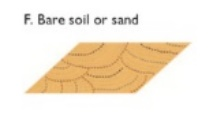 |
LCZ F – Bare soils or sand: Features unvegetated soil or sandy substrates, including construction sites, vacant lots, and natural areas undergoing erosion or desertification. |
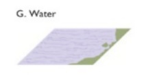 |
LCZ G – Water: Represents bodies of water such as lakes, rivers, and reservoirs, as well as aquatic ecosystems and urban waterways that influence local climate conditions through evaporative cooling and thermal inertia. |
Each LCZ class exhibits distinctive thermal properties, surface albedo, and roughness characteristics, which govern its impact on local climate conditions such as temperature, humidity, wind patterns, and the formation of urban heat islands. By systematically categorizing urban areas into discrete LCZ classes, the LCZ scheme provides a standardized framework for analyzing and comparing urban microclimates, facilitating interdisciplinary research, urban planning, and climate adaptation strategies tailored to the diverse needs and challenges of urban environments worldwide.
LCZ SCALE
The Local Climate Zones classification system operates across various spatial scales, integrating with broader scales of urban climate analysis. These scales range from micro-level assessments of individual urban elements to macro-level evaluations of entire metropolitan regions, encompassing a hierarchy of spatial extents that capture the diverse climatic influences within urban environments.
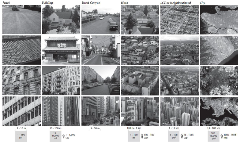
Facet Scale. Spanning 1 to 10 meters, this fine-grained analysis examines the thermal characteristics of individual surfaces and features within the urban environment, providing insights into localized microclimatic conditions, including temperature differentials of materials and solar radiation exposure.
Micro-Scale. Expanding from 10 to 100 meters, this is the scale of individual buildings and street canyons. This scale, known as Buildings and Street Canyon, which most directly influences pedestrian comfort and outdoor thermal quality, considers the thermal interactions between buildings, streets, and surrounding surfaces, shaping the microclimatic conditions within urban neighborhoods and districts.
Block Scale. Extending from 100 meters to 1 kilometer, the Block scale encompasses the aggregation of buildings and urban features within a city block or small neighborhood. Block-scale analyses capture the cumulative effects of building morphology, land use patterns, and surface cover types on local climate conditions. Block-scale assessments elucidate the thermal behavior of urban blocks, which constitute a crucial piece of local climate zones. Depending on the dimensions of the blocks, they can constitute an LCZ themselves.
Neighborhood Scale. This scale can be directly referred to as the LCZ or Neighborhood scale, spanning 1 to 10 kilometers. This scale considers the broader context of urban neighborhoods and districts within a city or metropolitan area, integrating multiple blocks and urban features and capturing the spatial heterogeneity of land use, vegetation cover, and built-up morphology. The LCZ-scale analyses assess the macroclimatic influences of urbanization on regional climate patterns, including urban heat island effects, precipitation patterns, and atmospheric circulation dynamics.
City or Marco-Scale. Expanding from 10 to 100 kilometers, the city scale encompasses the entire extent of a city or metropolitan region, integrating diverse urban and natural landscapes within a cohesive climatic framework. City-scale LCZ analyses provide a comprehensive understanding of the climatic footprint of cities, including their interactions with surrounding regions and ecosystems. City-scale assessments inform strategic planning and policy-making efforts to enhance urban resilience, mitigate climate change impacts, and promote sustainable development at the metropolitan scale.
Integration of Scales. LCZ analyses often rely on integrating multiple scales, leveraging insights from micro-climate to macro-scale assessments to capture the complexity and interconnectivity of urban climatic processes. Integrated climate analysis facilitates cross-disciplinary collaboration and decision-making, bridging the gap between urban climatology, urban planning, environmental science, and public health research. Synthesizing insights from different scales provides comprehensive assessments of urban climate resilience, supporting evidence-based interventions and adaptive strategies to address the challenges of climate change in urban environments.
LCZ PARAMETERS
Local Climate Zone classification relies on a set of parameters to characterize thermal behavior, surface cover, and morphological characteristics of the urban environments, enabling the classification of the different LCZ and the analysis of microclimatic conditions within cities. By integrating insights from these parameters, LCZ classification facilitates interdisciplinary research, urban planning, and climate adaptation strategies tailored to the diverse needs and challenges of urban environments worldwide.
- Sky View Factor (SVF). Sky View Factor represents the proportion of the visible sky hemisphere from a given point within the urban environment. It quantifies the openness of the sky above a specific location, influencing the availability of direct and diffuse solar radiation, as well as the potential for radiative cooling and heat exchange with the atmosphere.
- Aspect Ratio. Aspect Ratio refers to the mean height-to-width ratio of street canyons or building spacing. It characterizes the vertical profile and compactness of urban structures, influencing the absorption and re-radiation of solar energy, as well as air circulation patterns within urban canyons.
- Building Surface Fraction. Building Surface Fraction quantifies the proportion of the ground surface covered by buildings within a given area. It reflects the density and distribution of built structures, affecting the spatial distribution of surface temperatures, thermal inertia, and heat storage capacity within urban environments.
- Impervious Surface Fraction. The impervious Surface Fraction represents a fraction of the ground surface covered by impermeable materials such as pavement, concrete, and buildings. It influences surface runoff, heat absorption, and the urban heat island effect by reducing the availability of vegetative cover and evapotranspiration.
- Pervious Surface Fraction. Pervious Surface Fraction denotes the fraction of the ground surface covered by permeable materials such as vegetation, soil, and grass. It plays a crucial role in regulating surface runoff, enhancing infiltration and groundwater recharge, and mitigating the adverse impacts of urbanization on hydrological processes and water quality.
- Height of Roughness Elements. The height of Roughness Elements represents the vertical protrusion of urban features such as buildings, trees, and terrain irregularities. It influences air turbulence, wind speed distribution, and convective heat transfer within urban canyons, affecting the dispersion of pollutants and the ventilation of urban environments.
- Terrain Roughness Class. Terrain Roughness Class categorizes the surface roughness characteristics of urban areas based on the distribution and arrangement of surface features. It classifies urban landscapes into different roughness classes, ranging from smooth terrain with minimal obstacles to rough terrain with diverse surface features, influencing aerodynamic drag, wind profiles, and microscale meteorology.
- Surface Admittance. Surface Admittance represents the efficiency of surface-to-atmosphere energy exchange, quantifying the ability of urban surfaces to absorb or release heat. It accounts for surface properties such as thermal conductivity or emissivity, which govern the surface energy balance and heat fluxes within urban environments.
- Surface Albedo. Surface Albedo refers to the fraction of solar radiation reflected by the Earth’s surface back into the atmosphere. It characterizes the reflectivity of urban surfaces, including rooftops, pavements, and vegetation, influencing the absorption and redistribution of solar energy.
- Anthropogenic Heat Output. Anthropogenic Heat Output represents the heat generated by human activities within urban areas, including industrial processes, transportation, and building energy consumption. It contributes to the urban heat island effect, elevating temperatures and altering local climate conditions, particularly in densely populated urban cores and commercial districts.
LCZ THERMAL BEHAVIOUR
LCZ 1 – Compact High-Rise areas exhibit high thermal inertia due to the presence of tall buildings with significant thermal mass. During the day, these areas absorb and store solar radiation, leading to elevated surface temperatures and heat accumulation. At night, the dense urban fabric retains heat, resulting in prolonged periods of elevated temperatures and reduced nocturnal cooling compared to surrounding areas.
LCZ 2 – Compact Midrise areas feature medium-height buildings with moderate thermal mass and surface area-to-volume ratios. These areas experience less heat retention than Compact High-Rise zones but still exhibit elevated daytime temperatures due to the presence of impervious surfaces and limited vegetation. At night, Compact Midrise areas cool relatively quickly but may retain some residual heat due to urbanization effects.
LCZ 3 – Compact Low-Rise areas experience rapid heating and cooling cycles, with daytime temperatures influenced by solar exposure and nighttime temperatures moderated by enhanced radiative cooling. Compact Low-Rise zones may exhibit slightly cooler temperatures compared to higher-density urban areas due to increased convective heat loss.
LCZ 4 – Open High-Rise areas feature tall buildings surrounded by extensive open spaces, such as parks, plazas, or waterfronts. These areas experience significant diurnal temperature variations, with daytime temperatures influenced by solar exposure and surface albedo, while nighttime temperatures are moderated by enhanced radiative cooling and airflow. Open High-Rise zones may exhibit cooler daytime temperatures but can experience higher nocturnal cooling rates compared to compact urban areas.
LCZ 5 – Open Midrise areas comprise medium-height buildings interspersed with green spaces or low-density development. These areas exhibit moderate thermal inertia, with daytime temperatures influenced by building materials, vegetation cover, and surface albedo. Open Midrise zones typically experience cooler temperatures compared to compact urban areas due to increased surface evapotranspiration and shading effects.
LCZ 6 – Open Low-Rise areas exhibit low thermal inertia, with daytime temperatures moderated by vegetation cover, surface albedo, and wind exposure. Open Low-Rise zones benefit from enhanced evaporative cooling and shading effects, resulting in cooler daytime temperatures and more significant nocturnal cooling compared to denser urban areas.
LCZ 7 – Lightweight Low-Rise areas feature sparse development with minimal building density and vegetation cover. These areas experience rapid heating and cooling cycles, with daytime temperatures influenced by surface materials and wind exposure. Lightweight Low-Rise zones may exhibit warmer daytime temperatures but can experience rapid nocturnal cooling rates due to limited thermal mass and insulation.
LCZ 8 – Large Low-Rise areas exhibit high daytime heat absorption caused by large buildings and a limited vegetation cover. Nighttime cooling is moderate to rapid, depending on wind speed, resulting in cooler temperatures compared to denser urban areas. Thermal behavior is mainly influenced by building density, surface materials, and the presence of green spaces.
LCZ 9 – Sparsely Built areas comprise undeveloped or rural landscapes with minimal human activity and infrastructure. These areas experience natural thermal fluctuations driven by solar radiation, vegetation dynamics, and topographic features. LCZ 9 zones may exhibit cooler daytime temperatures and enhanced nocturnal cooling rates compared to urbanized areas, with thermal behavior influenced by local climatic and environmental factors.
LCZ 10 – Heavy Industry areas experience elevated temperatures due to industrial processes, waste heat generation, and reduced vegetative cover. LCZ 10 zones may exhibit higher daytime and nocturnal temperatures compared to surrounding areas, with thermal behavior influenced by industrial operations and emissions.
LCZ A – Dense Trees areas exhibit cooler daytime temperatures and enhanced nocturnal cooling rates due to shading, transpiration, and evapotranspiration processes. LCZ A zones provide natural thermal comfort and mitigate heat stress, with thermal behavior influenced by canopy cover, species composition, and vegetation density.
LCZ B – Scattered Trees areas provide localized shading and cooling effects, with daytime temperatures moderated by tree canopy cover and surface albedo. LCZ B zones exhibit cooler daytime temperatures and enhanced evaporative cooling compared to open urban areas, with thermal behavior influenced by tree distribution and density.
LCZ C – Bush, Scrub areas exhibit variable thermal behavior, with daytime temperatures influenced by surface materials, vegetation dynamics, and topographic features. LCZ C zones may exhibit warmer daytime temperatures and reduced nocturnal cooling rates compared to vegetated areas, with thermal behavior influenced by land use history and ecological succession.
LCZ D – Low Plants areas consist of grasslands, meadows, or herbaceous vegetation with low stature. These areas exhibit moderate thermal behavior, with daytime temperatures moderated by surface albedo, vegetation cover, and wind exposure. LCZ D zones provide limited shading and cooling effects compared to taller vegetation types, with thermal behavior influenced by evapotranspiration, seasonal growth patterns and management practices.
LCZ E – Bare Rock or Paved areas exhibit high thermal inertia and heat retention, with daytime temperatures elevated due to solar absorption and surface materials. LCZ E zones may exhibit warmer daytime temperatures and reduced nocturnal cooling rates compared to vegetated areas, with thermal behavior influenced by surface albedo and thermal conductivity.
LCZ F – Bare Soils or Sand areas exhibit extreme thermal fluctuations, with daytime temperatures influenced by solar exposure and surface materials. LCZ F zones may exhibit significantly warmer daytime temperatures and rapid nocturnal cooling rates compared to vegetated areas, with thermal behavior influenced by soil composition, moisture content, and surface roughness.
LCZ G – Water areas exhibit high thermal inertia and moderate temperature fluctuations, with daytime temperatures influenced by solar radiation and water depth. LCZ G zones provide natural cooling effects and support aquatic ecosystems, with thermal behavior influenced by water transparency, depth, and flow dynamics.
MAIN APPROACHES TO CLASSIFY LCZ
Classifying Local Climate Zones employs a range of strategies and methods to define the thermal, morphological, and land use features of urban areas. The establishment of LCZ categories is based on a blend of visual assessment and numerical analysis, which utilize remote sensing techniques based on satellite or aerial imagery, on-the-ground observations, Geographic Information Systems, and other advanced modeling techniques to capture the diverse and intricate nature of urban landscapes.
Field Surveys and Observations. Field surveys and direct observations play a fundamental role in LCZ classification, involving on-site assessments of urban morphology, land use patterns, and microclimatic conditions. Researchers and urban planners conduct systematic field surveys to collect data on building types, vegetation cover, surface materials, and other relevant parameters, allowing for the identification and classification of LCZ classes based on observed characteristics.
Remote Sensing and Satellite Imagery. Remote sensing techniques, including satellite imagery and aerial photography, provide valuable data for LCZ classification across large spatial extents. Satellite sensors capture multispectral and hyperspectral data, enabling the identification of surface cover types, urban features, and thermal properties from space. Remote sensing-based approaches utilize image classification algorithms, spectral indices, and machine learning techniques to classify LCZ classes and map urban land cover at regional and global scales.
GIS-Based Analysis. Geographic Information Systems (GIS) play a crucial role in LCZ classification by integrating spatial data layers, geospatial analysis tools, and statistical methods. GIS-based approaches utilize spatial databases, digital elevation models (DEM), land cover maps, and other georeferenced datasets to delineate LCZ boundaries, quantify urban characteristics, and analyze spatial patterns. GIS tools facilitate the spatial analysis of LCZ parameters, spatial interpolation, and modeling of urban climate processes, aiding in classifying and characterizing LCZ classes.
Machine Learning and Data Mining. Machine learning algorithms and data mining techniques are increasingly utilized for LCZ classification, leveraging computational methods to extract patterns and relationships from large datasets. Supervised and unsupervised learning algorithms, including support vector machines (SVM), random forests, and neural networks, are applied to remote sensing data, geospatial variables, and environmental parameters to automatically classify LCZ classes based on training samples and feature extraction techniques.
Urban Climate Models and Simulation. Urban climate models and simulation tools provide another approach to classify LCZ classes by simulating microclimatic conditions, heat transfer processes, and energy fluxes within urban environments. Numerical models such as ENVI-met, WRF-UCM, and Urban Weather Generator (UWG) simulate the interactions between buildings, vegetation, and the atmosphere, allowing for the prediction of temperature variations, wind patterns, and thermal comfort indices across different LCZ classes.
MAIN APPLICATIONS

The Local Climate Zones (LCZ) classification offers a versatile set of tools and methodologies applicable to a wide array of domains, from urban planning and environmental management to climate research and public health. By harnessing the insights derived from LCZ classification, stakeholders can embrace comprehensive approaches to address the intricate challenges posed by urbanization, climate change, and sustainable development. These approaches enable the cultivation of resilient, inclusive, and livable cities that cater to the needs of present and future generations.
Urban Planning and Design: LCZ classification provides urban planners and designers valuable insights into thermal behavior, microclimatic conditions, and city spatial patterns. By understanding the diverse characteristics of different LCZ classes, planners can develop context-specific design strategies, optimize building placement, and integrate green infrastructure to enhance urban resilience, mitigate heat island effects, and improve overall livability.
Environmental Management and Green Space Planning: LCZ classification facilitates the identification of areas with limited vegetation cover, impervious surfaces, and high building densities, highlighting priority areas for green space planning, urban greening initiatives, and ecosystem restoration projects. By promoting the preservation and expansion of green spaces within urban areas, LCZ-based strategies contribute to biodiversity conservation, carbon sequestration, and ecosystem services provision.
Climate Change Adaptation and Mitigation: LCZ classification aids in assessing the vulnerability of urban areas to climate change impacts and developing adaptation strategies to enhance resilience. By identifying areas prone to heat stress, flooding, and other climate-related hazards, LCZ-based approaches support the implementation of climate-responsive urban design measures, such as cool roofs, green roofs, permeable pavements, and urban forests, to mitigate heat island effects, reduce energy consumption, and enhance urban microclimates.
Public Health and Well-being: LCZ classification contributes to public health research by evaluating the relationship between urban environments, thermal comfort, and human health outcomes. By identifying areas with elevated temperatures and poor air quality, LCZ-based studies inform public health interventions aimed at reducing heat-related illnesses, respiratory diseases, and other health risks associated with urban heat islands. Additionally, LCZ-based urban design strategies promote outdoor comfort, physical activity, and social interaction, enhancing the overall well-being of urban residents.
Energy Efficiency and Building Performance: LCZ classification supports energy-efficient building design and urban energy planning by assessing the thermal characteristics and energy demand of different urban areas. By considering LCZ classes in building siting, orientation, and material selection, architects and engineers can optimize passive design strategies, enhance natural ventilation, and reduce heating and cooling loads. Additionally, LCZ-based energy modeling facilitates the evaluation of building performance, energy consumption patterns, and the effectiveness of energy conservation measures.
Transportation Planning and Mobility Management: LCZ classification informs transportation planning and mobility management strategies by identifying areas with high pedestrian activity, traffic congestion, and urban heat stress. By integrating LCZ data with transportation networks and land use patterns, planners can prioritize investments in active transportation infrastructure, pedestrian-friendly streetscapes, and shaded public spaces, promoting sustainable mobility options, reducing reliance on private vehicles, and improving urban accessibility and comfort.
Climate Research and Modeling: LCZ classification contributes to climate research and modeling efforts by providing detailed spatial data on urban land cover, surface properties, and microclimatic conditions. By incorporating LCZ data into regional climate models, researchers can better understand the urban heat island effect, urban-atmosphere interactions, and the impacts of urbanization on local and regional climate patterns. LCZ-based climate modeling enhances the accuracy of climate projections, urban climate assessments, and scenario planning for future climate change scenarios.
Policy Development and Decision-Making: LCZ classification informs policy development and decision-making processes at the local, regional, and national levels by providing evidence-based insights into urban environmental quality, sustainability, and resilience. By integrating LCZ data into urban planning policies, zoning regulations, and land use plans, policymakers can promote sustainable development, climate-responsive design, and equitable access to green spaces and urban amenities. LCZ-based policy interventions support informed decision-making, stakeholder engagement, and community participation in shaping the future of cities.
RELATED LINKS AND ADDITIONAL RESOURCES
- Bulletin of the American Meteorological Society – Journal Article: “Local Climate Zones for Urban Temperature Studies,” authored by I. D. Stewart and T. R. Oke, published in the Bulletin of the American Meteorological Society. It discusses the impact of urban development on local thermal climates, focusing on urban heat islands (UHIs) and introducing the “local climate zone” (LCZ) classification system. The LCZ system categorizes areas based on surface structure, cover, and human activity, providing a standardized framework for temperature observation characterization.
- Urban Climates – Cambridge University Press: The book “Urban Climates” hosted on the Cambridge University Press website, explores various aspects of urban climates, including their formation, characteristics, and impacts. It covers topics such as urban heat islands, air pollution, and microclimate dynamics within cities.
- Climate-Sensitive Design – Urban Climates: Section titled “Climate-Sensitive Design” within the book “Urban Climates” hosted on the Cambridge University Press website. The section discusses design considerations and strategies tailored to climate conditions in urban environments, offering insights into sustainable urban planning and architecture.
- WUDAPT – World Urban Database and Access Portal Tools: The WUDAPT project, which stands for World Urban Database and Access Portal Tools, is a global initiative to create a comprehensive database of worldwide urban areas classified according to the LCZ classification scheme. It provides valuable data and tools for urban climate research, modeling, classification, and analysis.
- LCZ Framework – WUDAPT: This link directs to the page within the WUDAPT project that provides information about the Local Climate Zone (LCZ) framework. LCZ is a classification system used to categorize urban areas based on their surface cover and structure, facilitating studies on urban climate and environmental impacts.
- Mapping local climate zones for cities: a comprehensive review of the LCZ mapping literature during 2012–2021, with a detailed analysis on literature statistics, research topics, LCZ cities, and active research groups. Furthermore, remote sensing (RS)-based LCZ mapping methods were elucidated from feature sets, classification units, training areas, classification algorithms, and accuracy assessment; geographic information system (GIS)-based LCZ mapping methods were elaborated from LCZ parameters, basic spatial units, classification algorithms, and accuracy assessment; and their combination methods.
- Top of FormA global map of local climate zones: A detailed global map of local climate zones (LCZs) at a 100 m spatial resolution. LCZs serve as a universal urban typology, distinguishing urban areas based on micro-scale land covers. This map aims to support environmental services, explore future urbanization pathways, and develop climate-sensitive urban planning policies. Achieved through labeled training areas and earth observation images, the map’s quality is assessed through cross-validation and benchmarking against functional urban areas. Ultimately, it facilitates model development and evidence-based urban planning.
- A global map of local climate zones: Dataset of global map of local climate zones (LCZs) at a 100 m spatial resolution.
- UN-Habitat – Urban Data: UN-Habitat provides access to a variety of datasets related to urban development and climate change. These datasets offer valuable information for analyzing and understanding urban environments, including data on population, infrastructure, housing, and environmental indicators.
*Images from
https://www.cambridge.org/core/books/urban-climates/A02424592E1C7F9B9CD69DAD57A5B50B
https://journals.ametsoc.org/view/journals/bams/93/12/bams-d-11-00019.1.xml


