TOPOGRAPHIC AND PLANIMETRIC DATA
GENERAL INFORMATION

Topographic and planimetric data are fundamental components of geospatial information used in urban planning and environmental science. These data types provide detailed information about the Earth’s surface, aiding in understanding terrain and the spatial arrangement of features.
Topographic Data:Topographic data encompasses information about the Earth’s surface elevation, capturing the vertical dimension of terrain features. Elevation models are often represented as Digital Elevation Models (DEMs) or digital terrain models (DTMs). These models can be generated through various methods, including satellite-based remote sensing, LiDAR (Light Detection and Ranging) technology, and aerial photogrammetry. This data is often represented as surface (raster) data and referred to as 2.5D data because it supports only a single z-value for each x,y location.
In addition to raster-based DEMs and DTMs, topographic data can be represented in vector form. Vector data stores elevation information using points, lines, and polygons with attributes that can include elevation values. This vector representation allows for more detailed and precise modeling of terrain features. Common formats for vector-based topographic data include shapefiles and geodatabases.
In urban planning, topographic data is essential for assessing the suitability of land for development, evaluating flood risks, and ensuring proper infrastructure design. In environmental science, topographic data supports the study of landforms, hydrological modeling, and the assessment of habitat suitability.
Planimetric Data:Planimetric data, on the other hand, deals with the horizontal positions and shapes of objects on the Earth’s surface. It provides two-dimensional spatial information without accounting for elevation. Planimetric data sources include high-resolution satellite imagery, aerial photography, and GPS surveys. In urban planning, planimetric data aids in land-use planning, transportation network design, and infrastructure layout. In environmental science, planimetric data is used to map land cover, analyze land use changes, and plan conservation efforts.
3D Feature Data:Includes vector data that provides information about the three-dimensional aspects. The 3D information for each object is stored in the feature’s geometry, which represents discrete objects. Three-dimensional feature data can potentially support many different z-values for each x,y location. This data extends the typical latitude and longitude 2-D coordinates by incorporating elevation and/or depth. A Z-value is added to the traditional 2D GIS data (x,y). Generally speaking, it combines topographic and planimetric data with vertical information.
MAIN SOURCES OF DATA
The creation of topographic and planimetric digital maps is a multifaceted endeavor that draws upon diverse data sources and processes. It encompasses the acquisition of data from satellites, aerial imaging, LiDAR technology, GPS, and surveys (involving the use of specialized surveying equipment such as theodolites and total stations). In the map production phase, a two-fold strategy is typically adopted. On one front, cartographers engage in precise on-screen digitization, meticulously tracing and digitizing features. On the other front, automatic classification processes employ sophisticated algorithms to identify and extract objects from remotely sensed data. This combination ensures efficiency and accuracy, with automation handling large-scale features, while manual digitization attends to intricate details. Rigorous validation and quality assurance measures, including ground truthing, are indispensable to maintain map accuracy.
- The United States Geological Survey (USGS) is a preeminent source for topographic and planimetric data in the United States. The National Map, a part of the USGS, provides comprehensive access to various datasets, including 3D Elevation Program (3DEP) data, topographic maps, and imagery.NASA’s Earth Observing System Data and Information System (EOSDIS) is a global source for Earth science data. The Advanced Spaceborne Thermal Emission and Reflection Radiometer (ASTER) and the Ice, Cloud, and Land Elevation Satellite-2 (ICESat-2) contribute to elevation and planimetric datasets.
The National Aerial Photography Program (NAPP), administered by the USGS, provides aerial imagery captured from aircraft. This imagery serves as a valuable source for planimetric data, including detailed information about roads, buildings, and land cover in the United States.
These resources are invaluable for urban planning and environmental science applications within the U.S. and worldwide.
- OpenStreetMap (OSM) is a collaborative, open-source mapping platform where contributors worldwide provide geospatial data. It offers valuable data for urban planning and environmental science, including geographical features, land use, buildings, transportation networks, points of interest, and more, making it a versatile resource for these fields.
- Companies like DigitalGlobe and Airbus offer high-resolution satellite imagery, including the WorldView and Pleiades satellites. These sources are beneficial for acquiring up-to-date planimetric data for urban planning and environmental studies worldwide.
DATA FOR MILAN
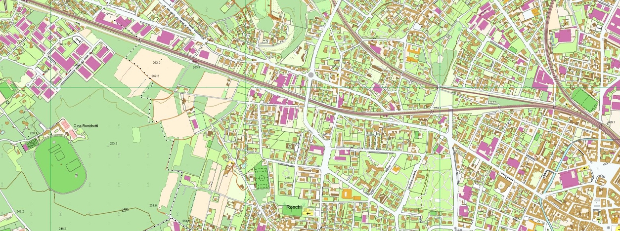
Lombardy Region provides access to the Geo-Topographic Database (DBGT), which serves as the geographic and topographic reference base for the regional Territorial Information System and is integral for creating planning and territorial programming tools at various administrative levels.
The regional DBGT 2.0 is derived from the compilation and reprocessing of local “first-generation” Topographic Databases (DBT) produced by individual municipalities, associations of municipalities, mountain communities, and provinces, with additional contributions from the Lombardy Region.
The DBGT is entirely created using the aerial photogrammetric methodology, which involves the direct numerical restitution of aerial photographs. This methodology is primarily applied at a scale of 1:2,000 for urbanized areas, 1:5,000 for non-urban areas, and 1:10,000 for mountainous areas or regions with little to no urbanization.
The structure of the DBGT adheres to the current national specifications, and its content is updated through the data provided by local public administrations.
DATA FOR BARCELONA
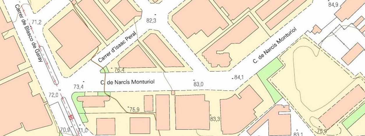
The Cartographic and Geological Institute of Catalonia (Institut Cartogràfic i Geològic de Catalunya – ICGC) offers access to topographic cartography data at a 1:1,000 scale. This resource provides detailed topographic maps at a high resolution, making it a valuable source for geospatial projects, urban planning, environmental science, and research activities within Catalonia, Spain. The topographic maps cover various geographic features, land use, and terrain information, serving as a fundamental tool for spatial analysis and decision-making processes in the region. Researchers, urban planners, and geospatial professionals can benefit from these detailed maps to support a wide range of applications, including land use planning, environmental assessments, and infrastructure development.
Main Characteristics are:
- Contour lines with a 1-meter interval.
- Accuracy: 20 cm in planimetry (horizontal positioning) and 25 cm in altimetry (elevation data).
- Available formats: DXF (CAD), DGN (CAD), SHP (GIS), and KMZ (Google Earth, for buildings only).
MAIN APPLICATIONS

Urban Planning
Land Use and Zoning:Topographic data is crucial for assessing the suitability of land for different purposes, including residential, commercial, and industrial zones. It aids in optimizing land use, designing infrastructure, and determining zoning regulations for urban development.
Transportation Planning:Planimetric data is essential for designing efficient road networks, optimizing traffic flow, and determining the locations of public transportation routes. It also supports the development of pedestrian and cyclist-friendly infrastructure.
Flood Risk Assessment:Topographic data is indispensable for modeling and assessing flood risks in urban areas. It helps in identifying flood-prone areas and planning flood protection measures.
Urban Growth Analysis:Topographic and planimetric data are used to monitor and manage urban expansion, analyze population growth trends, and plan for sustainable urban development.
Environmental Science
Ecosystem Monitoring:Topographic and planimetric data are critical for assessing terrain and land cover changes in ecosystems. These data help environmental scientists track deforestation, habitat loss, and the effects of climate change on natural landscapes.
Natural Resource Management:These data support the sustainable management of natural resources such as water bodies, forests, and mineral deposits. They aid in evaluating the environmental impact of resource extraction and land use changes.
Climate Change Analysis:Topographic data is used to analyze the effects of climate change on landscapes, including glacier retreat, sea-level rise, and shifts in vegetation zones. This information is vital for understanding the Earth’s changing environment.
Habitat Conservation:Planimetric data is crucial for habitat conservation as it enables the precise mapping and monitoring of critical habitats for species. By providing accurate spatial information, it aids in identifying habitat boundaries, planning wildlife corridors, and implementing protection measures.
RELATED LINKS AND ADDITIONAL RESOURCES
Further background information
- National Geospatial-Intelligence Agency (NGA): NGA’s website provides access to information about their Geospatial Sciences division, which offers in-depth knowledge of geospatial concepts, technologies, and applications. It serves as an educational resource for gaining a deeper understanding of the field.
- European Space Agency (ESA): The Copernicus program’s official website offers extensive documentation, reports, and publications related to its Earth observation missions. These resources provide insights into the program’s goals and outcomes.
- United States Geological Survey (USGS): The USGS National Geospatial Program offers access to technical documentation, specifications, and standards for using their topographic and planimetric data.
- ArcGIS – Fundamentals of 3D Data: This link provides insights into the fundamentals of 3D geospatial data and its applications, offering valuable knowledge for those working with three-dimensional geospatial information.
- SERC Carleton – Topographic Data: This resource is a valuable source of information on topographic data, offering insights into its applications and significance in the field of geospatial information.
- USGS – What is a Topographic Map?: This link explains what a topographic map is and why it is essential in various applications, providing foundational knowledge about topographic mapping.
- Penn State E-Education – Nature of Geospatial Information: Topographic Data: This educational resource delves into the nature of topographic data, providing in-depth information about its characteristics and applications in the geospatial domain.
Accessing and working Data
- United States Geological Survey (USGS): The USGS, a primary source for topographic and planimetric data, offers access to their datasets through The National Map. This platform provides a comprehensive repository for various geospatial data, including DEMs, imagery, and maps.
- European Space Agency (ESA): The Copernicus program provides free access to a wealth of Sentinel satellite data. It is a valuable resource for users interested in obtaining satellite imagery for Earth observation applications.
- NASA Earthdata: The NASA Earthdata platform is a one-stop resource for discovering and downloading a wide range of Earth science data, including satellite imagery and elevation data. It is a key source for accessing geospatial data for various applications.
- OpenStreetMap (OSM): OSM offers a user-friendly interface for downloading global planimetric data, including map data in various formats, making it a versatile source for geospatial information.
- National Aerial Photography Program (NAPP): The USGS NAPP Viewer allows users to explore and download aerial imagery captured by the program. This resource is particularly useful for planimetric data, including detailed information about roads, buildings, and land cover in the United States.
- Maxar Open Data Program: Maxar’s Open Data Program offers free access to satellite imagery for non-commercial use, supporting a wide range of applications, including urban planning and environmental science.
- Regione Lombardia Geoportale: This resource from Regione Lombardia provides access to geospatial data, including the Database Geo-Topografico (DBGT) and metadata, offering valuable datasets for urban planning and environmental science applications.
- Institut Cartogràfic i Geològic de Catalunya (ICGC): The ICGC offers access to vectorial cartography data, including topographic and planimetric data, which can be a valuable resource for geospatial projects and analysis in Catalonia, Spain.
*Images from

