TREE CANOPY COVER
GENERAL INFORMATION

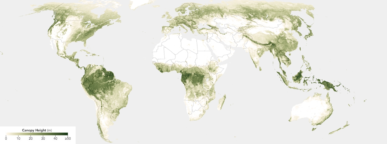
The Tree Canopy represents the uppermost layer of vegetation, predominantly composed of tree branches, leaves, and stems. It is a vital component of ecosystems, contributing significantly to ecological and aesthetic qualities. Tree canopies can be found in various landscapes, including forests, woodlands, parks, rural areas, and urban environments. Tree canopies’ composition, density, and health vary significantly depending on the specific environment and the tree species present. Understanding the characteristics and extent of tree canopies is vital for researchers, conservationists, and policymakers seeking to comprehend and manage natural and urban landscapes.
Urban Tree Canopy (UTC)
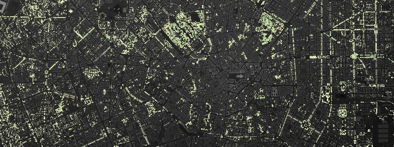
Within the broader context of tree canopy, the Urban Tree Canopy (UTC) constitutes a specific sub-category for urban and suburban environments. It encompasses the upper layer of trees in cities and surrounding areas, including residential neighborhoods, parks, streets, and other urban landscapes.
Urban Tree Canopies share many attributes with their non-urban counterparts but face unique challenges and opportunities. They play a crucial role in enhancing the urban environment and contributing to the overall well-being of city residents. Understanding and managing the UTC is particularly significant for urban planners, environmental scientists, and policymakers aiming to create sustainable and resilient cities.
Tree Canopy serves as nature’s carbon sink. Trees capture atmospheric carbon dioxide (CO2) through photosynthesis and store it as biomass, reducing greenhouse gas concentrations. The removal of CO2 from the air contributes to mitigating climate change. The presence of healthy UTC in cities significantly influences local climate. Trees provide shade, reducing surface temperatures and the urban heat island effect. By cooling the urban environment, they reduce the energy consumption required for air conditioning and help combat rising temperatures associated with global warming. Trees also act as natural air filters. They reduce air pollutants, including particulate matter, improving air quality and reducing health risks for urban residents. Ultimately, beyond their ecological contributions, trees enhance the quality of urban life, creating pleasing environments and offering spaces for leisure, relaxation, and outdoor activities, contributing to residents’ physical and mental well-being.
MAIN SOURCES AND SENSORS TO GET TREE CANOPY
Tree canopy data can be obtained through various sources and sensors, each offering unique capabilities for capturing critical canopy structure and health information. Some of the primary sources and sensors are:
- High-resolution optical sensors on satellites like WorldView-3, Pléiades, Sentinel-2, or Landsat provide detailed imagery suitable for tree canopy analysis. These sensors capture multispectral and panchromatic data, enabling the detection of variations in canopy health, species diversity, and urban forest composition. Satellites such as Pléiades (1A and 1B) are enhanced with stereoscopic capabilities that provide high-resolution imagery suitable for creating 3D models of tree canopies, hence obtaining very high-resolution Digital Surface Models (DSM).
- LiDAR-equipped satellites or airborne provide precise elevation data in the form of (X, Y, and Z) point clouds, essential for modeling tree canopies in 3D. These sensors offer unparalleled accuracy in measuring canopy height, structure, and biomass, making them invaluable for forestry and environmental research.
- Digital aerial cameras, often mounted on aircraft or drones, capture high-resolution Ortho imagery of tree canopies. These cameras have various spectral bands, allowing researchers to analyze map and tree canopy health.
- Additional sources and sensors, including hyperspectral and thermal cameras, can provide complementary data for comprehensive tree canopy analysis. These sensors can offer insights into tree physiology, stress detection, and water content.
TECHNIQUES FOR GENERATING TREE CANOPY
There are several techniques for collecting tree canopy cover data. Photogrammetry techniques are used extensively for image feature extraction. However, they require high computational processing for ultra-high-resolution UAV datasets. LiDAR technology can penetrate thick vegetation, such as forest canopies, to gather surface elevation data and detect objects hidden to the human eye or other electro-optical methods. Machine learning techniques have also been employed for canopy classification problems. High-resolution optical sensors perform a wide range of mapping and analytical applications.
Photogrammetry Based on Satellite Stereo Images.Photogrammetry is a technique that derives detailed information about tree canopies using high-resolution stereo satellite imagery. Photogrammetry allows for extracting tree height, canopy size, and foliage density data by analyzing pairs of images captured from slightly different angles. This information aids in the comprehensive analysis of tree canopy structure and health.
LiDAR (Light Detection and Ranging).LiDAR technology is pivotal in creating Digital Surface Models (DSM) encompassing tree canopy cover. LiDAR sensors emit laser pulses and measure the time it takes for these pulses to return. This process generates highly precise elevation models, distinguishing between ground surfaces and tree canopies. LiDAR is instrumental in accurately mapping and analyzing tree canopies across diverse environments.
Machine Learning from Very High-Resolution Imagery.Machine learning algorithms can be trained to automatically identify and classify tree canopies in exceptionally high-resolution satellite or aerial imagery. This approach entails training models on extensive labeled image datasets, enabling automated recognition of tree species, canopy coverage estimation, and continuous monitoring of changes. Machine learning enhances the efficiency and precision of tree canopy mapping.
Hyperspectral Remote Sensing.Hyperspectral sensors capture data across a wide range of spectral bands, providing information about vegetation’s chemical and physiological properties. This data can identify tree species, assess tree health, and detect stress factors such as disease or pollution. Hyperspectral imagery enhances our understanding of the composition and condition of tree canopies.
Drone-Based Remote Sensing.Unmanned aerial vehicles (UAVs or drones) with various sensors, including RGB cameras, multispectral cameras, and LiDAR, offer a flexible and cost-effective means of capturing high-resolution tree canopy data. Drones can be deployed for targeted surveys in specific areas of interest and can provide detailed information on tree canopy structure and health.
MAIN APPLICATIONS OF TREE CANOPY COVER DATA

Tree canopy cover data has numerous applications. It is used to examine watershed conditions, make scenario-based projections of future canopy cover, and as input to i-Tree, an urban forestry tool that helps users understand their current tree cover and plan for new tree plantings. It also plays an essential role in conservation. Moreover, it can be used to better understand how communities are at risk from natural disasters and what can be done to mitigate large-scale natural disasters. Overall, tree canopy cover data finds diverse applications, with a particular focus on addressing climate change and global warming:
- Biodiversity:Urban and rural tree canopies provide essential habitats for wildlife, supporting local biodiversity and ecological balance.
- Forest Management:Foresters and land managers utilize canopy data to monitor forest health, assess timber resources, and make informed decisions regarding logging and conservation practices.
- CO2 Sequestration:Accurate assessments of tree canopy cover enable the quantification of carbon sequestration rates, helping policymakers and researchers understand the role of urban forests in carbon balance.
- Sustainable Water ManagementUnderstanding tree canopy cover assists sustainable water management by reducing stormwater runoff, minimizing erosion, and enhancing groundwater recharge. This contributes to urban resilience against extreme weather events.
- Thermal Comfort:Urban tree canopies reduce heat stress by providing shade and lowering temperatures in urban areas. This improves residents’ comfort and reduces energy consumption for cooling, contributing to climate adaptation efforts.
- Urban Greening:In urban planning, tree canopy data informs decisions on tree planting, urban green spaces, and mitigating urban heat island effects, leading to improved urban environments.
- Aesthetics and Well-Being:Trees in urban environments enhance aesthetics, promote community well-being, and encourage outdoor physical activity. These benefits contribute to the overall livability of cities.
- Economic Benefits:Lush tree canopies in urban and suburban areas can increase property values and attract businesses, yielding economic benefits for communities.
RELATED LINKS AND ADDITIONAL RESOURCES
Further background information about Tree Canopy Cover:
- Urban Tree Canopy Assessment | U.S. Climate Resilience Toolkit: This website provides a tool for urban tree canopy assessment and its role in climate resilience.
- U.S. Environmental Protection Agency: This website explains how trees help reduce runoff and the benefits of soaking up the rain.
- City of Edmond: This website explains why urban tree canopy and its environmental benefits are essential.
- Center for Watershed Protection: This website provides information on urban tree canopy and its role in stormwater management.
- Forestami: A project promoted by the Metropolitan City of Milan, the Municipality of Milan, the Regional Council of Lombardy, Parco Nord Milano, Parco Agricolo Sud Milano, ERSAF (Regional Agency for Agricultural and Forestry).
Accessing and working with very Tree Canopy Cover:
- Google Environmental Insights Explorer: Google Environmental Insights Explorer (EIE) is a platform that offers comprehensive information and data related to sustainability efforts, focusing on providing valuable insights and resources related to the tree canopy and its role in environmental conservation.
- USDA Forest Service Tree Canopy Cover: This resource from the USDA Forest Service specializes in delivering geospatial data and tools related explicitly to tree canopy cover. It is a valuable source for accessing detailed information about tree canopy coverage in various geographic areas.
- Multi-Resolution Land Characteristics (MRLC) – Tree Canopy Data: The Multi-Resolution Land Characteristics (MRLC) program provides extensive datasets related to tree canopy cover, utilizing remote sensing data to create detailed and comprehensive tree canopy coverage information.
- MIT Senseable City Lab – Treepedia: Treepedia, developed by MIT’s Senseable City Lab, is a dedicated project that explores and provides information about urban tree canopy cover. It offers interactive maps and visualizations to assess and compare worldwide tree canopy coverage in cities.
- i-Tree Canopy: The i-Tree Canopy is part of the i-Tree suite and is specifically designed for assessing and analyzing tree canopy cover in specific areas. It is a valuable resource for understanding tree canopy’s ecological and economic benefits in urban environments.
- Global 30m Landsat Tree Canopy Data: This resource provides access to global tree canopy data derived from Landsat satellite imagery. It serves as a valuable source of information about tree canopy coverage on a global scale, supporting various environmental and research applications with a specific emphasis on tree canopy data.
*Images from
https://earthobservatory.nasa.gov/images/149793/scientists-show-how-forests-measure-up

